Rivers
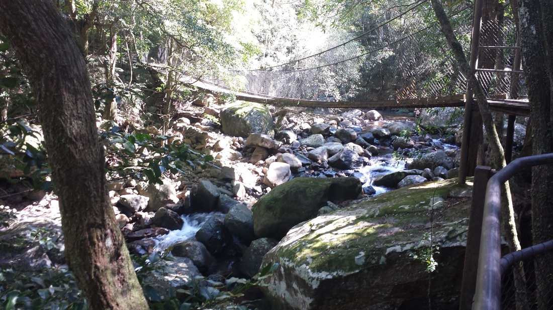
Watercourse through Minnamurra rainforest
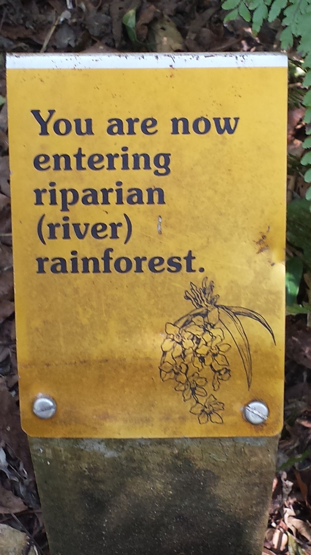
Riparian Rainforest

The are three types of rainforest which exist in the Minnamurra area. They are subtropical, warm temperate rainforest and riparian rainforest.
Subtropical Rainforest
Subtropical rainforests develop in environments with fertile soils and high rainfall, and are similar to tropical rainforests, although has slightly fewer species. This particularly applies to the canopy of a subtropical rainforest. The main characteristics of a subtropical rainforest include:
Warm Temperate Rainforest
Warm temperate rainforests grow at higher altitudes, in less fertile soils and cooler climates than subtropical rainforests. These rainforests, when compared to subtropical rainforests, have order and uniformity. Characteristics of warm temperate rainforests include:
Riparian Rainforest
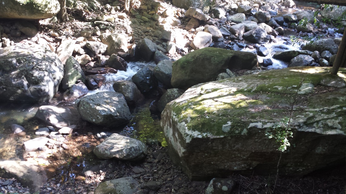
The Riparian rainforest exists along the river gully. Riparian means "next to" or "adjacent to a water body". The rainforest in this area is more sheltered from the drying westerly winds and fires and therefore is more abundant because of a larger supply of rainfall, fertile soils and moisture-laden air. Riparian zones are transition zones between an upland terrestrial environment and an aquatic environment. Organisms found in this zone are adapted to periodic flooding. Many not only tolerate it, but require it in order to maintain health and complete their lifestyles. Some common characteristics of a Riparian forest include:
Activity: The waterway looks fairly calm in the photo below. What type of extreme natural climatic event do you think led to the boulders shown in the photo being deposited in this area? What size particles would you expect this waterway to normally erode, transport and deposit?
Subtropical Rainforest
Subtropical rainforests develop in environments with fertile soils and high rainfall, and are similar to tropical rainforests, although has slightly fewer species. This particularly applies to the canopy of a subtropical rainforest. The main characteristics of a subtropical rainforest include:
- a mixed composition of many species with no obvious domination by any one species
- trees of large to medium size with a range of leaf forms and sizes
- palms, strangler figs, buttressed trunks, large vines and large epiphytes, such as orchids and ferns, are common and diverse.
Warm Temperate Rainforest
Warm temperate rainforests grow at higher altitudes, in less fertile soils and cooler climates than subtropical rainforests. These rainforests, when compared to subtropical rainforests, have order and uniformity. Characteristics of warm temperate rainforests include:
- two tree layers
- vegetation less diverse than in subtropical rainforests, with as few as three species making up the canopy
- leaf size on average smaller than in subtropical rainforest.
- leaves usually simple with toothed margins
- no buttress roots
- vines thin and wirey
- no palms and stranglers: some large epiphytes and vines but they are not abundant or diverse.
Riparian Rainforest
The Riparian rainforest exists along the river gully. Riparian means "next to" or "adjacent to a water body". The rainforest in this area is more sheltered from the drying westerly winds and fires and therefore is more abundant because of a larger supply of rainfall, fertile soils and moisture-laden air. Riparian zones are transition zones between an upland terrestrial environment and an aquatic environment. Organisms found in this zone are adapted to periodic flooding. Many not only tolerate it, but require it in order to maintain health and complete their lifestyles. Some common characteristics of a Riparian forest include:
- subject to frequent inundation/flooding.
- helping control sediments which reduce the damaging effects of flooding and aid in stabilizing river banks.
Activity: The waterway looks fairly calm in the photo below. What type of extreme natural climatic event do you think led to the boulders shown in the photo being deposited in this area? What size particles would you expect this waterway to normally erode, transport and deposit?
|
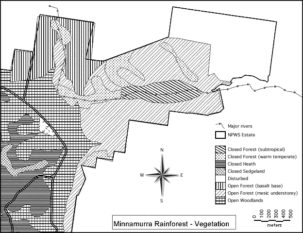
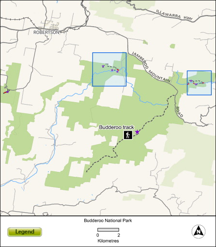
Activity: Using GIS the below map was created depicting both the tropical and warm temperate parts of the rainforest. Using the information you have learnt hypothesise and propose where the Riparian rainforest would occur. Include in your portfolio
|
Minnamurra River
|
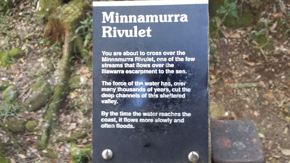
The catchment for the Minnamurra Rivulet covers almost half of the Kiama municipality. A maze of little creeks and bogs feed into the river from Knights Hill through Jamberoo Valley to the seaside village of Minnamurra just north of Kiama. The river spills out into the sea at Minnamurra Beach. By the time the Minnamurra River reaches the coast, the river is slow and wide. It is surrounded by mudflats formed from the silt it has carried down from the escarpment over thousands of years and more recently, from the expose soils of the Jamberoo Valley following the extensive clearing of rainforest in the 19th century.
|
Geographical processes
Rocks
Along its journey, the river has cut its way through the complex layers of volcanic and sedimentary rocks, such as Budgong Sandstone, erode faster than the latite layers. This has resulted in the formation of the Jamberoo Valley, where the river has eroded through the tuffS to the harder latite bedrock.
Clues to the different types of rock state dissected by the river can be seen in the variety of rocks that lie scattered along its bed. For example the dark grey, smooth rocks are latite (blue metal); the yellowish gritty rocks are Hawkesbury Sandstone; the grey and crumbly rocks that split along flat planes are shale and the black rocks are coal.
As can be seen in the diagram of the geology of the Minnamurra area, there are varying bedrocks throughout the Minnamurra Rainforest, with sandstones and volcanic rocks being the dominant types. These would produce podzolics from the sedimentary sandstone materials and kraznozems from the volcanic materials. The type of bedrock affects the soil type and this in turn affects the type of forests which grow in that soil. Sandstone-based soils tend to be less fertile than volcanic based soils and are therefore normally associated with warm temperate rainforest in this area; whilst volcanic soils are quite fertile and tend to be associated with the more abundant subtropical forest.
Soils
Soil in the rainforest is very important because of the role that it plays in recycling the organic matter from the forest floor into a form that the trees can use for further growth. Soils in the rainforest tend to have a profile that is not very deep but which is very high in organic matter near the surface, with not much organic matter past the top layers as it is highly leached because of the high rainfall.
In a rainforest the soil tends to be more acid because of the leaf litter on the ground. Secondly, fauna can affect soil by burrowing into it, eating organic matter and excreting it in other parts of the soil profile, where it might be more useful in its more broken-down form. Examples include worms which use organic matter for food, then burrow, moving some organic matter into the top layer of soil as they go, and depositing digested matter in this layer and further down. This helps to make the soil healthier by allowing air into the deeper layers and improving drainage. Organisms are one of five factors that affect soil formation; the others are bedrock, the climate, topography, and time.
There are varying bedrocks throughout the Minnamurra Rainforest, with sandstones and volcanic rocks being the dominant types. These would produce podzolics from the sedimentary sandstone materials and kraznozems from the volcanic materials. The type of bedrock affects the soil type and this in turn affects the type of forests which grow in that soil. Sandstone-based soils tend to be less fertile than volcanic based soils and are therefore normally associated with warm temperate rainforest in this area; whilst volcanic soils are quite fertile and tend to be associated with the more abundant subtropical forest.
Climate can affect soil because the amount of rainfall influences how quickly organic matter, nutrients and minerals are moved through the soil profile and how quickly they break down. This is also affected by temperature. If an area is likely to have rainforest it will tend to have a warm, wet climate. This leads to soils that are highly leached and quick at breaking down organic matter. In addition lime, or calcium carbonate, which makes soils alkaline, is soluble in water, so this is quickly dissolved and leached out of the soil, leaving an acid soil.
Topography affects soils because the position of soil on a slope or on flat ground affects how quickly water drains either off or through it. If soil is located on a slope, some of the water that falls as rainfall will not penetrate the soil profile but will drain straight over the soil towards a lower point. Flat land, in the same rainfall area, will have more of the rain infiltrate into the soil profile. This means that the effects of water as described above are more noticeable on flat land than on adjoining slopes, which will have drier soil despite the same rainfall. This affects the rainforest because it means that volcanic soils, where we would expect to see subtropical rainforest, there may be warm temperate rainforest instead, because the soil will not be moist enough to support subtropical plants. In addition, if a slope faces the direction of the strongest winds it will tend to be dried out, making conditions less favourable for subtropical rainforest, whilst slopes facing away from the wind are often more protected, and it is more likely that subtropical rainforest will grow there.
Time affects soils because the older the soil, the more developed it is, in terms of where minerals, nutrients and organic matter are found in the profile. Generally older soils will have had time to move these things down the profile. However, once soils attain a certain age, they reach an equilibrium where the minerals etc. are moved through the profile and taken up by plants at a constant rate. This continues as long as the organisms that affect that soil continue to exist undisturbed. Rainforest soils have generally reached this equilibrium, so it is hard to tell how old they are apart from saying they are old enough to be well developed.
Activity: Looking at the geological cross-section below, together with the topographic map and the satellite photo of Minnamurra Rainforest, construct a precis map of the area showing approximately the soil variation.
|
|
| ||||||
Activity: Around the rivers and rivulets in Minnamurra we will expect to find alluvial soils (soils made from nutrient rich sediments dropped after floods) over the soils that result from the bedrock. How will this affect the type of rainforest you will find there? Add this to your precis maps and include the map in your portfolio.
Where the River meets the Ocean
Minnamurra Rivulet travels thought the Minnamurra Rainforest, over Illawara Escarpment and out through Minnamurra beach.
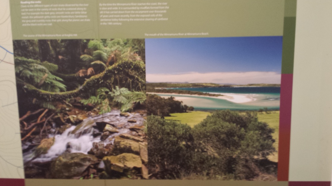
Left: Knights Hill - Source of Minnamurra River.
Right: Where the Minnamurra River meets the ocean at Minnamurra Beach.
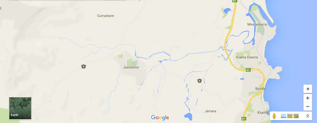
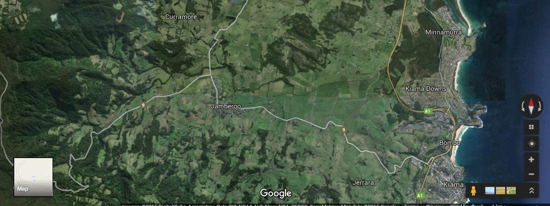
Activity: Compare the map and satellite image. Mark clearly on the satellite image the route the river takes.
|
|
Activity: Once you have marked the river on the satellite image, investigate how the river is used and annotate land use of the image. Include both images in your portfolio.
